
Haz una donación
Mapa topográfico Luther
Haga clic en el mapa para ver la altitud.
Haz una donación
Acerca de este mapa
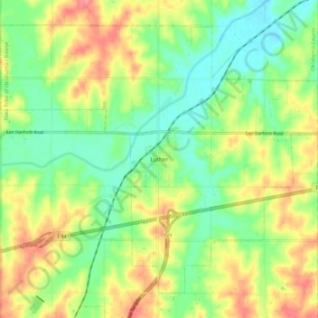
Nombre: Mapa topográfico Luther, altitud, relieve.
Lugar: Luther, Oklahoma County, Oklahoma, 73054, United States (35.62333 -97.24718 35.69601 -97.14114)
Altitud media: 296 m
Altitud mínima: 266 m
Altitud máxima: 335 m
Haz una donación
Otros mapas topográficos
Haga clic en un mapa para ver su topografía, su altitud y su relieve.
Newalla
United States > Oklahoma > Oklahoma County > Oklahoma City
Newalla, with a current elevation of 1,148 feet, is located within the Eastern bounds of Oklahoma County and appears on the Harrah, Oklahoma U.S. Geological Survey Map due to their proximity. Newalla is a geographic area which spans unincorporated Oklahoma County and unincorporated Cleveland County (also…
Altitud media: 343 m
Haz una donación
Lightning Creek Holding Pond B Dam
United States > Oklahoma > Oklahoma County > Oklahoma City
Altitud media: 386 m
Haz una donación