
Mapa topográfico Gilford
Mapa interactivo
Haga clic en el mapa para ver la altitud.
Acerca de este mapa
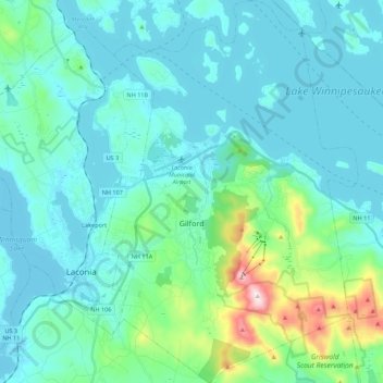
Nombre: Mapa topográfico Gilford, altitud, relieve.
Lugar: Gilford, Belknap County, New Hampshire, 03249, United States (43.48157 -71.45817 43.64057 -71.31150)
Altitud media: 231 m
Altitud mínima: 146 m
Altitud máxima: 720 m
According to the United States Census Bureau, the town has a total area of 53.6 square miles (138.7 km2), of which 38.8 sq mi (100.5 km2) are land and 14.7 sq mi (38.2 km2) are water, comprising 27.56% of the town. Belknap Mountain, elevation 2,384 feet (727 m) above sea level and the highest point in Gilford as well as Belknap County, is in the south. Much of the town is drained by the Gunstock River, a tributary of Lake Winnipesaukee. Gilford lies fully within the Merrimack River watershed.
Otros mapas topográficos
Haga clic en un mapa para ver su topografía, su altitud y su relieve.
Lake Winnipesaukee
United States > New Hampshire > Belknap County > Alton
Lake Winnipesaukee, Alton, Belknap County, New Hampshire, 03226, United States
Altitud media: 223 m
The Plains
United States > New Hampshire > Belknap County > Tilton
The Plains, Tilton, Belknap County, New Hampshire, 03252, United States
Altitud media: 167 m
Mallard Cove
United States > New Hampshire > Belknap County > Laconia
Mallard Cove, Laconia, Belknap County, New Hampshire, 03246, United States
Altitud media: 173 m
Sanbornton
United States > New Hampshire > Belknap County
Sanbornton, Belknap County, New Hampshire, 03269, United States
Altitud media: 228 m
Tilton
United States > New Hampshire > Belknap County
Tilton, Belknap County, New Hampshire, United States
Altitud media: 196 m
Meredith
United States > New Hampshire > Belknap County
Meredith, Belknap County, New Hampshire, 03253, United States
Altitud media: 215 m
Barnstead
United States > New Hampshire > Belknap County
Barnstead, Belknap County, New Hampshire, United States
Altitud media: 221 m