
Mapa topográfico Apponaug
Mapa interactivo
Haga clic en el mapa para ver la altitud.
Acerca de este mapa
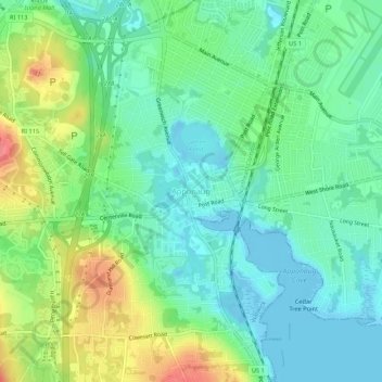
Nombre: Mapa topográfico Apponaug, altitud, relieve.
Lugar: Apponaug, Kent County, Rhode Island, 02886, United States (41.68038 -71.47978 41.72038 -71.43978)
Altitud media: 23 m
Altitud mínima: -8 m
Altitud máxima: 69 m
Otros mapas topográficos
Haga clic en un mapa para ver su topografía, su altitud y su relieve.
Anthony
United States > Rhode Island > Kent County > Coventry
Anthony, Coventry, Kent County, Rhode Island, 02816, United States
Altitud media: 71 m
East Greenwich
United States > Rhode Island > Kent County
East Greenwich, Kent County, Rhode Island, 02818, United States
Altitud media: 21 m
Coventry
United States > Rhode Island > Kent County
Coventry, Kent County, Rhode Island, United States
Altitud media: 126 m
Crompton
United States > Rhode Island > Kent County > West Warwick
Crompton, West Warwick, Kent County, Rhode Island, 02893, United States
Altitud media: 63 m
West Greenwich
United States > Rhode Island > Kent County > West Greenwich
West Greenwich, Kent County, Rhode Island, 02817, United States
Altitud media: 111 m
Warwick
United States > Rhode Island > Kent County
Warwick, Kent County, Rhode Island, United States
Altitud media: 34 m