
Mapa topográfico Tempo
Mapa interactivo
Haga clic en el mapa para ver la altitud.
Acerca de este mapa
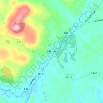
Nombre: Mapa topográfico Tempo, altitud, relieve.
Altitud media: 127 m
Altitud mínima: 79 m
Altitud máxima: 264 m
Otros mapas topográficos
Haga clic en un mapa para ver su topografía, su altitud y su relieve.
Belcoo
United Kingdom > Northern Ireland > County Fermanagh
Belcoo, County Fermanagh, Ulster, Northern Ireland, BT93 5FB, United Kingdom
Altitud media: 86 m
Moher
United Kingdom > Northern Ireland > County Fermanagh
Moher, Lea, County Fermanagh, Ulster, Northern Ireland, BT92 4FJ, United Kingdom
Altitud media: 65 m
Horse Island
United Kingdom > Northern Ireland > County Fermanagh
Horse Island, County Fermanagh, Ulster, Northern Ireland, United Kingdom
Altitud media: 46 m
Heron Island
United Kingdom > Northern Ireland > County Fermanagh
Heron Island, County Fermanagh, Ulster, Northern Ireland, United Kingdom
Altitud media: 47 m