
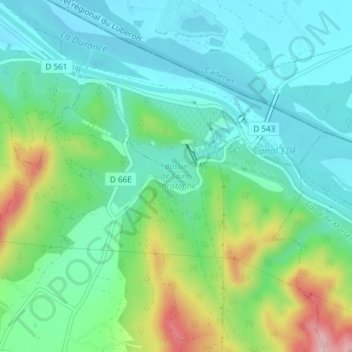
Mapa topográfico Bassin de Saint-Christophe
Mapa interactivo
Haga clic en el mapa para ver la altitud.
Acerca de este mapa
Nombre: Mapa topográfico Bassin de Saint-Christophe, altitud, relieve.
Altitud media: 202 m
Altitud mínima: 145 m
Altitud máxima: 352 m
Otros mapas topográficos
Haga clic en un mapa para ver su topografía, su altitud y su relieve.
La Jacourelle
France > Provence-Alpes-Côte d'Azur > Bouches-du-Rhône > La Roque-d'Anthéron
La Jacourelle, La Roque-d'Anthéron, Aix-en-Provence, Bouches-du-Rhône, Provence-Alpes-Côte d'Azur, France métropolitaine, 13640, France
Altitud media: 258 m
Village Vacances de La Baume
France > Provence-Alpes-Côte d'Azur > Bouches-du-Rhône > La Roque-d'Anthéron
Village Vacances de La Baume, La Roque-d'Anthéron, Aix-en-Provence, Bouches-du-Rhône, Provence-Alpes-Côte d'Azur, France métropolitaine, 13640, France
Altitud media: 225 m