
Gracias por apoyar a este sitio ❤️
Haz una donación
Haz una donación
Mapa topográfico Stringtown
Haga clic en el mapa para ver la altitud.
Gracias por apoyar a este sitio ❤️
Haz una donación
Haz una donación
Acerca de este mapa
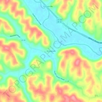
Nombre: Mapa topográfico Stringtown, altitud, relieve.
Altitud media: 230 m
Altitud mínima: 183 m
Altitud máxima: 290 m
Gracias por apoyar a este sitio ❤️
Haz una donación
Haz una donación
Otros mapas topográficos
Haga clic en un mapa para ver su topografía, su altitud y su relieve.
Gracias por apoyar a este sitio ❤️
Haz una donación
Haz una donación
Amesville
United States > Ohio > Athens County
Amesville is situated in the foothills of the Appalachian Mountains, approximately 45 miles south by southeast of the terminal moraine, a topographical feature often associated with the boundaries of glaciers, and is surrounded by wooded hills, narrow valleys, and numerous creeks flanked by lowland pastures…
Altitud media: 223 m
Gracias por apoyar a este sitio ❤️
Haz una donación
Haz una donación