
Mapa topográfico La Prise Tarot
Mapa interactivo
Haga clic en el mapa para ver la altitud.
Acerca de este mapa
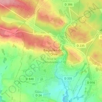
Nombre: Mapa topográfico La Prise Tarot, altitud, relieve.
Altitud media: 194 m
Altitud mínima: 143 m
Altitud máxima: 254 m
Otros mapas topográficos
Haga clic en un mapa para ver su topografía, su altitud y su relieve.
Les Milles Mottes
France > Normandie > Orne > Bagnoles-de-l'Orne-Normandie > Bagnoles-de-l'Orne
Les Milles Mottes, Bagnoles-de-l'Orne, Bagnoles-de-l'Orne-Normandie, Alençon, Orne, Normandie, France métropolitaine, 61140, France
Altitud media: 191 m
Loup Pendu
France > Normandie > Orne > Bagnoles-de-l'Orne-Normandie > Bagnoles-de-l'Orne
Loup Pendu, Bagnoles-de-l'Orne, Bagnoles-de-l'Orne-Normandie, Alençon, Orne, Normandie, France métropolitaine, 61140, France
Altitud media: 190 m