
Mapa topográfico São Brás de Alportel
Mapa interactivo
Haga clic en el mapa para ver la altitud.
São Brás de Alportel
During the 19th century the parish became an important economic center. Cork oak plantations encouraged commercial development and made São Brás de Alportel the largest cork producing center in Portugal. At the beginning of the 20th century (1912), São Brás de Alportel was the most populated parish in the Faro municipality, with about 12,500 inhabitants. The economic and population expansion of the parish was a decisive factor for its elevation to municipality. The movement in defense of the autonomy of São Brás de Alportel emerged in the beginning of the 20th century, motivated by the economic growth of the village. It is the Republican Parish Commission that takes on the organization of the movement, which gains strength from 1910 onwards, as the political conditions are more favorable and the old supporters of republican propaganda, acquittances of João Rosa Beatriz, are in the government. Many barriers were raised to the pretensions of the republicans of São Brás. João Rosa Beatriz went to Lisbon several times, requesting the support of several personalities that proved to be decisive for the realization of that desire. In December 1912, its revolutionary leader Machado Santos presented, in the Portuguese Parliament, the bill granting administrative autonomy to the then most populous parish in the municipality of Faro. Through the efforts and diligence of João Rosa Beatriz, the bill was approved and published in the Diário do Governo, on June 1, 1914, elevating the parish of São Brás to a municipality, with the denomination of Alportel and with its headquarters in the village of São Brás. In the course of events, a provisional Administrative Commission was created, presided by Virgílio de Passos. To install the new Municipality, and after heated struggles, on September 5, was authorized the cession of the Episcopal Palace and respective fence and parish residence to the Alportel Town Council, to operate the official primary schools and public schools and the public, municipal and State offices. On October 14 of that year, João Rosa Beatriz was appointed by the Civil Governor of Faro, as interim administrator of the municipality (a position equivalent to the one we know today as Mayor), establishing as priorities public education, security and maintenance of public order, as well as accessibility to the town of São Brás de Alportel. On November 8, the first Municipal Commission of São Brás de Alportel was elected, with José Pereira da Machada as President of the Senate. A short time later, a sudden political change altered the course of events. The democratic government had appointed a new Civil Governor for the district of Faro, who in turn removed João Rosa Beatriz from his post, replacing him with José Baptista Dias Gomes. Once removed from his post, João Rosa Beatriz did not stop professing his ideals and his love for the land where he was born, fighting for several benefits for his town: the installation of a mobile library in the town, the creation of a municipal notary's office, the placement of a rural letter carrier in the municipality and the installation of the railway linking Loulé to São Brás. In April 1916, during a violent riot, the battalion of volunteers that he headed at the time also played a fundamental role in re-establishing public order in São Brás. At the time the world was watching the destruction caused by the First World War. Many young men recruited by the army left São Brás de Alportel, while others sought new directions for their businesses and their lives.
Acerca de este mapa
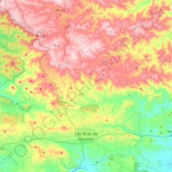
Nombre: Mapa topográfico São Brás de Alportel, altitud, relieve.
Lugar: São Brás de Alportel, Faro, Portugal (37.12252 -7.96600 37.26877 -7.78492)
Altitud media: 322 m
Altitud mínima: 116 m
Altitud máxima: 529 m
Otros mapas topográficos
Haga clic en un mapa para ver su topografía, su altitud y su relieve.
São Brás de Alportel
Portugal > Faro > São Brás de Alportel > São Brás de Alportel
Altitud media: 254 m