
Haz una donación
Mapa topográfico Cincinnati
Haga clic en el mapa para ver la altitud.
Haz una donación
Cincinnati
Cincinnati has several standard modes of transportation including sidewalks, roads, public transit, bicycle paths and airports. The city's hills preclude the regular street grid common to many cities built up in the 19th century, and outside of the downtown basin, regular street grids are rare except for in patches of flat land where they are small and oriented according to topography.
Haz una donación
Acerca de este mapa
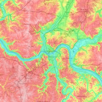
Nombre: Mapa topográfico Cincinnati, altitud, relieve.
Lugar: Cincinnati, Hamilton County, Ohio, 45202, United States (38.94145 -84.67246 39.26145 -84.35246)
Altitud media: 225 m
Altitud mínima: 139 m
Altitud máxima: 293 m
Haz una donación
Otros mapas topográficos
Haga clic en un mapa para ver su topografía, su altitud y su relieve.
Cincinnati
United States > Ohio > Hamilton County
Cincinnati features a distinctive topography characterized by its rolling hills and valleys. The city is situated on the north bank of the Ohio River, where the terrain rises sharply from the riverfront, reaching elevations of approximately 980 feet (299 meters) in some areas. The average elevation throughout…
Altitud media: 222 m
Cincinnati
United States > Ohio > Hamilton County
Cincinnati has several standard modes of transportation including sidewalks, roads, public transit, bicycle paths and airports. The city's hills preclude the regular street grid common to many cities built up in the 19th century, and outside of the downtown basin, regular street grids are rare except for in…
Altitud media: 222 m
Loveland
United States > Ohio > Hamilton County
According to the United States Census Bureau, the city has a total area of 5.00 square miles (12.95 km2), of which 4.93 square miles (12.77 km2) is land and 0.07 square miles (0.18 km2) is water. The city is situated at an elevation of 597 ft (182 m) above sea level.
Altitud media: 222 m
Haz una donación
Haz una donación
Norwood
United States > Ohio > Hamilton County
The earliest humans in the area now known as Norwood are believed to have been Pre-Columbian era people of the Adena culture. Norwood Mound, a prehistoric earthwork mound built by the Adena, is located in Norwood and listed on the National Register of Historic Places. The Adena constructed the mound at the…
Altitud media: 196 m
Haz una donación
Haz una donación
Haz una donación
Haz una donación
Haz una donación
Camp John McLean Memorial Park
United States > Ohio > Hamilton County > Wyoming > Park Place
Altitud media: 207 m
Haz una donación
Loveland
United States > Ohio > Hamilton County
According to the United States Census Bureau, the city has a total area of 5.00 square miles (12.95 km2), of which 4.93 square miles (12.77 km2) is land and 0.07 square miles (0.18 km2) is water. The city is situated at an elevation of 597 ft (182 m) above sea level.
Altitud media: 222 m
Haz una donación
Haz una donación
Cincinnati
United States > Ohio > Hamilton County
Cincinnati has several standard modes of transportation including sidewalks, roads, public transit, bicycle paths and airports. The city's hills preclude the regular street grid common to many cities built up in the 19th century, and outside of the downtown basin, regular street grids are rare except for in…
Altitud media: 222 m
Haz una donación
French Park
United States > Ohio > Hamilton County > Amberley Village > Rolling Knolls Estate
Altitud media: 235 m
Haz una donación
Norwood
United States > Ohio > Hamilton County
The earliest humans in the area now known as Norwood are believed to have been Pre-Columbian era people of the Adena culture. Norwood Mound, a prehistoric earthwork mound built by the Adena, is located in Norwood and listed on the National Register of Historic Places. The Adena constructed the mound at the…
Altitud media: 196 m
Cincinnati
United States > Ohio > Hamilton County
Cincinnati has several standard modes of transportation including sidewalks, roads, public transit, bicycle paths and airports. The city's hills preclude the regular street grid common to many cities built up in the 19th century, and outside of the downtown basin, regular street grids are rare except for in…
Altitud media: 222 m
Haz una donación
Haz una donación
Cincinnati
United States > Ohio > Hamilton County
Cincinnati has several standard modes of transportation including sidewalks, roads, public transit, bicycle paths and airports. The city's hills preclude the regular street grid common to many cities built up in the 19th century, and outside of the downtown basin, regular street grids are rare except for in…
Altitud media: 222 m
Haz una donación
Haz una donación