
Haz una donación
Mapa topográfico Montalban
Haga clic en el mapa para ver la altitud.
Haz una donación
Montalban
Rodriguez is generally very rough in topography, with 83% of its total land area composed of upland areas, hills and mountain ranges. The remaining 17% low-lying terrain and rolling lands are found at the south-western portion of the municipality, along with the northern portions of the Municipality of San Mateo.
Haz una donación
Acerca de este mapa
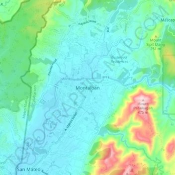
Nombre: Mapa topográfico Montalban, altitud, relieve.
Lugar: Montalban, Rizal, Calabarzon, 1860, Philippines (14.69247 121.10527 14.77247 121.18527)
Altitud media: 99 m
Altitud mínima: 8 m
Altitud máxima: 459 m
Haz una donación
Otros mapas topográficos
Haga clic en un mapa para ver su topografía, su altitud y su relieve.
Haz una donación
Haz una donación
Haz una donación
Haz una donación
Haz una donación
Muzon
Philippines > Rizal > Taytay
The shape of Taytay is rectangular – trapezoidal with gently hilly rolling terrain on its eastern side while relatively flat on its south-western side, including the poblacion. The municipality's highest elevation ranges from 200 to 255 meters which is situated along the inner north-eastern hills of Barangay…
Altitud media: 28 m