
Haz una donación
Mapa topográfico Pranjani
Haga clic en el mapa para ver la altitud.
Haz una donación
Acerca de este mapa
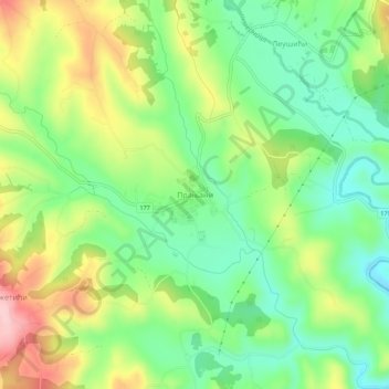
Nombre: Mapa topográfico Pranjani, altitud, relieve.
Altitud media: 422 m
Altitud mínima: 343 m
Altitud máxima: 545 m
Haz una donación
Otros mapas topográficos
Haga clic en un mapa para ver su topografía, su altitud y su relieve.
Pranjani
Serbia > Central Serbia > Moravica Administrative District > Gornji Milanovac Municipality
Altitud media: 484 m
Pranjani
Serbia > Central Serbia > Moravica Administrative District > Gornji Milanovac Municipality
Altitud media: 484 m
Gornji Milanovac
Serbia > Central Serbia > Moravica Administrative District > Gornji Milanovac Municipality
Gornji Milanovac and the villages of Varnice, Zagradje, Dragolj and Trudelj are dominated by the Ostrvica Massif. The elevation of Ostrvica is 758 metres (2,487 ft). Ostrvica is actually the remains of a destroyed volcanic cone. In May 2009, Ostrvica was declared a natural monument. In the middle of the last…
Altitud media: 377 m
Donja Vrbava
Serbia > Central Serbia > Moravica Administrative District > Gornji Milanovac Municipality
Altitud media: 534 m
Haz una donación
Zagradje
Serbia > Central Serbia > Moravica Administrative District > Gornji Milanovac Municipality
Altitud media: 409 m
Ozrem
Serbia > Central Serbia > Moravica Administrative District > Gornji Milanovac Municipality
Altitud media: 459 m
Trudelj
Serbia > Central Serbia > Moravica Administrative District > Gornji Milanovac Municipality
Altitud media: 394 m