
Gracias por apoyar a este sitio ❤️
Haz una donación
Haz una donación
Mapa topográfico Eccles Pike
Haga clic en el mapa para ver la altitud.
Gracias por apoyar a este sitio ❤️
Haz una donación
Haz una donación
Eccles Pike
At the top of the hill is a commemorative plaque known as a topograph, showing a 360° relief of the surrounding landscape, placed by the community to mark the millennium. In early November 2011, the topograph was stolen. On 7 May 2013, it was replaced with one made from less valuable metal to discourage future theft.
Gracias por apoyar a este sitio ❤️
Haz una donación
Haz una donación
Acerca de este mapa
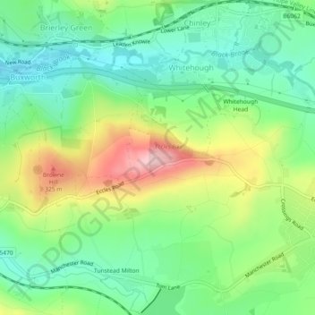
Nombre: Mapa topográfico Eccles Pike, altitud, relieve.
Altitud media: 233 m
Altitud mínima: 161 m
Altitud máxima: 361 m
Gracias por apoyar a este sitio ❤️
Haz una donación
Haz una donación