
Haz una donación
Mapa topográfico Lake Powell
Haga clic en el mapa para ver la altitud.
Haz una donación
Lake Powell
Concrete placement started around the clock on June 17, 1960. The last bucket of concrete was poured on September 13, 1963. Over 5 million cubic yards (4,000,000 m³) of concrete make up Glen Canyon Dam. The dam is 710 feet (216 m) high and the surface elevation of the water at full-pool is approximately 3700 feet (1100 m). Construction of the dam cost $155 million, and 18 lives were lost in the process. From 1970 to 1980, turbines and generators were installed for hydroelectricity. On September 22, 1966, Glen Canyon Dam was dedicated by Lady Bird Johnson.
Haz una donación
Acerca de este mapa
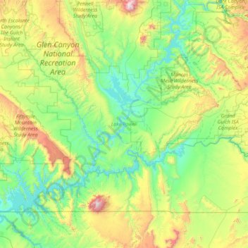
Nombre: Mapa topográfico Lake Powell, altitud, relieve.
Lugar: Lake Powell, Kane County, Utah, United States (36.84441 -111.56748 37.90938 -110.28672)
Altitud media: 1.555 m
Altitud mínima: 1.103 m
Altitud máxima: 3.236 m
Haz una donación
Otros mapas topográficos
Haga clic en un mapa para ver su topografía, su altitud y su relieve.