
Mapa topográfico Kimberley
Mapa interactivo
Haga clic en el mapa para ver la altitud.
Acerca de este mapa
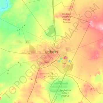
Nombre: Mapa topográfico Kimberley, altitud, relieve.
Altitud media: 1.191 m
Altitud mínima: 1.091 m
Altitud máxima: 1.314 m
Kimberley is set in a relatively flat landscape with no prominent topographic features within the urban limits. The only "hills" are debris dumps generated by more than a century of diamond mining. From the 1990s these were being recycled and poured back into De Beers Mine (by 2010 it was filled to within a few tens of metres of the surface). Certain of the mine dumps, in the vicinity of the Big Hole, have been proclaimed as heritage features and are to be preserved as part of the historic industrial landscape of Kimberley.