
Haz una donación
Mapa topográfico Bhavnagar
Haga clic en el mapa para ver la altitud.
Haz una donación
Bhavnagar
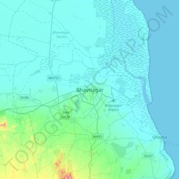
Bhavnagar is a coastal city on the eastern coast of Saurashtra, also known as Kathiawar, located at 21°46′N 72°09′E / 21.77°N 72.15°E / 21.77; 72.15. It has an average elevation of 24 metres or 78.7 feet. It occupies an area of 53.3 square kilometres or 20.6 square miles and is the fifth most populated city of Gujarat. The general slope dips towards the northeast at the apex of Gulf of Khambhat. A small non-perennial river named Kansara Nala passes through the outer area of the city.
Haz una donación
Acerca de este mapa
Nombre: Mapa topográfico Bhavnagar, altitud, relieve.
Lugar: Bhavnagar, Bhavnagar Taluka, Bhavnagar, Gujarat, 364001, India (21.61188 71.98164 21.93188 72.30164)
Altitud media: 23 m
Altitud mínima: -1 m
Altitud máxima: 247 m
Haz una donación