Mapa topográfico Bogart
Mapa interactivo
Haga clic en el mapa para ver la altitud.
Acerca de este mapa
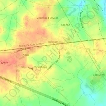
Nombre: Mapa topográfico Bogart, altitud, relieve.
Lugar: Bogart, Oconee County, Georgia, United States (33.93142 -83.54875 33.96081 -83.51678)
Altitud media: 244 m
Altitud mínima: 217 m
Altitud máxima: 263 m
Otros mapas topográficos
Haga clic en un mapa para ver su topografía, su altitud y su relieve.
North High Shoals
United States > Georgia > Oconee County
North High Shoals, Oconee County, Georgia, United States
Altitud media: 214 m
Watkinsville
United States > Georgia > Oconee County
Watkinsville, Oconee County, Georgia, 30644, United States
Altitud media: 218 m