
Haz una donación
Mapa topográfico Of
Haga clic en el mapa para ver la altitud.
Haz una donación
Of
There are several stories about the origins of Of's name. Of was called Ofis in 1910 by Pontic Greek speaking inhabitants. According to another view it means "village" or "settlement" in the Laz language (Laz: ოფუტე/oput'e), as the old name of the town is mentioned as "Opiunte" on the Tabula Peutingeriana. By another version of events, the city got its name from a nearby river described by Arrian as Ophis, a Greek word for "snake". The Ophius stream - which snakes (zigzags) its way from around 3300 meters altitude in the Pontic Mountains towards the coastal town of Of - was renamed as "Solaklı" during the 1950s Turkification process which is a common policy in all of Turkey.
Haz una donación
Acerca de este mapa
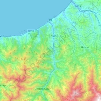
Nombre: Mapa topográfico Of, altitud, relieve.
Lugar: Of, Trabzon, Black Sea Region, 61830, Turkey (40.77508 40.18978 40.98833 40.47715)
Altitud media: 414 m
Altitud mínima: 0 m
Altitud máxima: 1.897 m
Haz una donación
Otros mapas topográficos
Haga clic en un mapa para ver su topografía, su altitud y su relieve.
Haz una donación
Haz una donación