
Mapa topográfico Buctouche Harbour
Mapa interactivo
Haga clic en el mapa para ver la altitud.
Acerca de este mapa
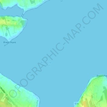
Nombre: Mapa topográfico Buctouche Harbour, altitud, relieve.
Altitud media: 2 m
Altitud mínima: -1 m
Altitud máxima: 19 m
Otros mapas topográficos
Haga clic en un mapa para ver su topografía, su altitud y su relieve.
Bouctouche
Canada > New Brunswick > Bouctouche
Bouctouche, Wellington Parish, Kent County, New Brunswick, Canada
Altitud media: 16 m
Saint-Jean-Baptiste
Canada > New Brunswick > Bouctouche
Saint-Jean-Baptiste, Bouctouche, Wellington Parish, Kent County, New Brunswick, E4S 2T6, Canada
Altitud media: 7 m