
Mapa topográfico Capelas
Mapa interactivo
Haga clic en el mapa para ver la altitud.
Capelas
The first settlements congregated around the port of Poços, along the northern edge that divides Capelas from São Vicente Ferreira; its first settlers establishing shelters in and around the 16th Century. With elevation of Capelas to (religious) parish it became integrated within the municipality of Ponta Delgada (on 11 July 1592). This administrative dependency lasted until it was elevated to status of vila, as stipulated by the Carta de Lei (Charter Law) conferred by Queen D. Maria, on July 10, 1839.
Acerca de este mapa
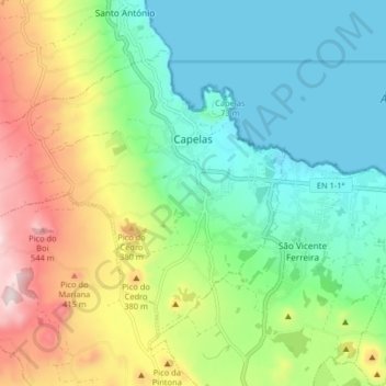
Nombre: Mapa topográfico Capelas, altitud, relieve.
Lugar: Capelas, Ponta Delgada, Azores, Portugal (37.80425 -25.75047 37.85171 -25.66940)
Altitud media: 195 m
Altitud mínima: 0 m
Altitud máxima: 588 m
Otros mapas topográficos
Haga clic en un mapa para ver su topografía, su altitud y su relieve.