
Mapa topográfico Boulder
Mapa interactivo
Haga clic en el mapa para ver la altitud.
Acerca de este mapa
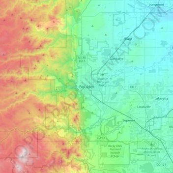
Nombre: Mapa topográfico Boulder, altitud, relieve.
Lugar: Boulder, Boulder County, Colorado, 80306, United States (39.85499 -105.43055 40.17499 -105.11055)
Altitud media: 1.977 m
Altitud mínima: 1.495 m
Altitud máxima: 3.187 m
Boulder is located at the base of the foothills of the Rocky Mountains, at an elevation of 5,430 feet (1,655 m) above sea level. Boulder is 25 miles (40 km) northwest of the Colorado State Capitol in Denver. It is home of the main campus of the University of Colorado, the state's largest university.
Otros mapas topográficos
Haga clic en un mapa para ver su topografía, su altitud y su relieve.
Wonderland Lake
United States > Colorado > Boulder County > Boulder
Wonderland Lake, Boulder, Boulder County, Colorado, United States
Altitud media: 1.739 m
Fredrick Law Olmsted, Jr. Park
United States > Colorado > Boulder County > Boulder
Fredrick Law Olmsted, Jr. Park, Washington Village, Boulder, Boulder County, Colorado, United States
Altitud media: 1.664 m
Chautauqua Park
United States > Colorado > Boulder County > Boulder
Chautauqua Park, Boulder, Boulder County, Colorado, United States
Altitud media: 1.774 m
University of Colorado Boulder (Williams Village)
United States > Colorado > Boulder County > Boulder
University of Colorado Boulder (Williams Village), Boulder, Boulder County, Colorado, United States
Altitud media: 1.634 m
National Center for Atmospheric Research
United States > Colorado > Boulder County > Boulder
National Center for Atmospheric Research, Skunk Canyon Trail, Boulder, Boulder County, Colorado, 80310, United States
Altitud media: 1.816 m
Seven Hills
United States > Colorado > Boulder County > Boulder > Seven Hills
Seven Hills, Boulder, Boulder County, Colorado, United States
Altitud media: 1.985 m