
Haz una donación
Mapa topográfico Lake Placid
Haga clic en el mapa para ver la altitud.
Haz una donación
Lake Placid
Lake Placid, located in Highlands County, Florida, is situated on relatively flat terrain characteristic of the Florida Peninsula. The town's average elevation is approximately 150 feet (46 meters) above sea level, with elevations ranging from a minimum of about 69 feet (21 meters) to a maximum of about 165 feet (50 meters). This gentle topography is typical of the region, contributing to the area's suitability for agriculture and outdoor recreational activities. The landscape is predominantly flat, with subtle undulations and low-lying areas, interspersed with numerous lakes and wetlands that enhance the area's natural beauty. The presence of these water bodies, such as Lake Placid itself, adds to the scenic charm and ecological diversity of the region.
Haz una donación
Acerca de este mapa
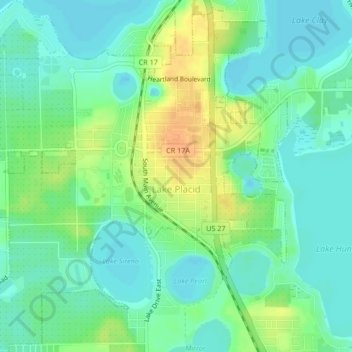
Nombre: Mapa topográfico Lake Placid, altitud, relieve.
Lugar: Lake Placid, Highlands County, Florida, 33852, United States (27.27582 -81.39029 27.31301 -81.34960)
Altitud media: 32 m
Altitud mínima: 20 m
Altitud máxima: 53 m
Haz una donación
Otros mapas topográficos
Haga clic en un mapa para ver su topografía, su altitud y su relieve.
Haz una donación
Haz una donación