
Haz una donación
Mapa topográfico Adin
Haga clic en el mapa para ver la altitud.
Haz una donación
Acerca de este mapa
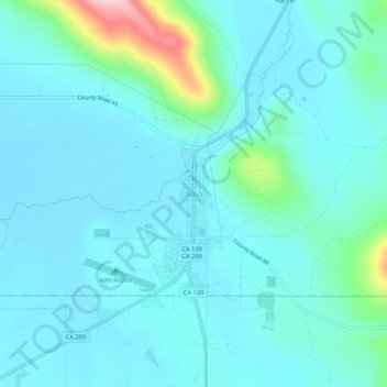
Nombre: Mapa topográfico Adin, altitud, relieve.
Lugar: Adin, Modoc County, California, 96006, United States (41.17484 -120.96423 41.21484 -120.92423)
Altitud media: 1.308 m
Altitud mínima: 1.274 m
Altitud máxima: 1.508 m
Haz una donación
Otros mapas topográficos
Haga clic en un mapa para ver su topografía, su altitud y su relieve.
Alturas
United States > California > Modoc County
Alturas (Spanish for "Heights"; Achumawi: Kasalektawi) is the only incorporated city in Modoc County, California of which it is also the county seat. Located in the Shasta Cascade region of Northern California, the city had a population of 2,715 at the 2020 census. Alturas is located at the confluence of the…
Altitud media: 1.337 m
Alturas
United States > California > Modoc County
Alturas (Spanish for "Heights"; Achumawi: Kasalektawi) is a city and the county seat of Modoc County, California. Located in the Shasta Cascade region of Northern California, the city had a population of 2,715 at the 2020 census. Alturas is located at the confluence of the south and north forks of the Pit…
Altitud media: 1.336 m
Haz una donación