
Mapa topográfico Town of Namakagon
Mapa interactivo
Haga clic en el mapa para ver la altitud.
Acerca de este mapa
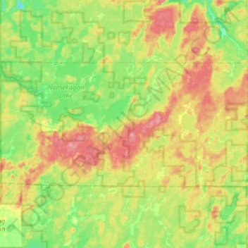
Nombre: Mapa topográfico Town of Namakagon, altitud, relieve.
Lugar: Town of Namakagon, Bayfield County, Wisconsin, United States (46.15460 -91.17635 46.24250 -90.92410)
Altitud media: 443 m
Altitud mínima: 404 m
Altitud máxima: 496 m
Otros mapas topográficos
Haga clic en un mapa para ver su topografía, su altitud y su relieve.
Raspberry Island
United States > Wisconsin > Bayfield County
Raspberry Island, Town of Russell, Bayfield County, Wisconsin, United States
Altitud media: 182 m
Houghton Point
United States > Wisconsin > Bayfield County
Houghton Point, Town of Bayview, Bayfield County, Wisconsin, United States
Altitud media: 192 m
Town of Kelly
United States > Wisconsin > Bayfield County
Town of Kelly, Bayfield County, Wisconsin, United States
Altitud media: 281 m
Sand Bay
United States > Wisconsin > Bayfield County > Sand Bay
Sand Bay, Town of Russell, Bayfield County, Wisconsin, United States
Altitud media: 209 m