
Mapa topográfico Madison
Mapa interactivo
Haga clic en el mapa para ver la altitud.
Acerca de este mapa
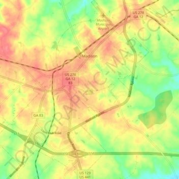
Nombre: Mapa topográfico Madison, altitud, relieve.
Lugar: Madison, Morgan County, Georgia, United States (33.54487 -83.51538 33.61875 -83.43872)
Altitud media: 195 m
Altitud mínima: 156 m
Altitud máxima: 225 m
Madison is located at 33°35′17″N 83°28′21″W / 33.58806°N 83.47250°W / 33.58806; -83.47250 (33.588038, -83.472368). According to the United States Census Bureau, the city has a total area of 8.9 square miles (23 km2), of which, 8.9 square miles (23 km2) of it is land and 0.04 square miles (0.10 km2) of it (0.45%) is water. Madison is situated on a high ridge which traverses Morgan County from the northeast to the southwest at an elevation of 760 feet.
Otros mapas topográficos
Haga clic en un mapa para ver su topografía, su altitud y su relieve.
Bostwick
United States > Georgia > Morgan County
Bostwick, Morgan County, Georgia, United States
Altitud media: 221 m
Rutledge
United States > Georgia > Morgan County
Rutledge, Morgan County, Georgia, United States
Altitud media: 211 m
Fairplay
United States > Georgia > Morgan County
Fairplay, Morgan County, Georgia, United States
Altitud media: 223 m