
Mapa topográfico Lourdes
Mapa interactivo
Haga clic en el mapa para ver la altitud.
Acerca de este mapa
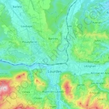
Nombre: Mapa topográfico Lourdes, altitud, relieve.
Altitud media: 514 m
Altitud mínima: 358 m
Altitud máxima: 1.082 m
Lourdes lies at an elevation of 420 m (1,380 ft) and in a central position through which runs the fast-flowing river Gave de Pau from the south, coming from its source at Gavarnie; into it flow several smaller rivers from Barèges and Cauterets. The Gave then branches off to the west towards the Béarn, running past the banks of the Grotto and on downstream to Pau and then Biarritz.