
Gracias por apoyar a este sitio ❤️
Haz una donación
Haz una donación
Mapa topográfico Witter
Haga clic en el mapa para ver la altitud.
Gracias por apoyar a este sitio ❤️
Haz una donación
Haz una donación
Acerca de este mapa
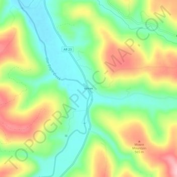
Nombre: Mapa topográfico Witter, altitud, relieve.
Lugar: Witter, Madison County, Arkansas, 72776, United States (35.91758 -93.70352 35.95758 -93.66352)
Altitud media: 494 m
Altitud mínima: 419 m
Altitud máxima: 598 m
Gracias por apoyar a este sitio ❤️
Haz una donación
Haz una donación
Otros mapas topográficos
Haga clic en un mapa para ver su topografía, su altitud y su relieve.
Saint Paul
United States > Arkansas > Madison County
St. Paul is located in the Upper Boston Mountains ecoregion. The ecoregion is generally higher and moister than the Lower Boston Mountains; elevations vary from 1,900 to 2,800 feet (580 to 850 m). Potential natural vegetation is oak–hickory forest. Characteristically, the forests of the Upper Boston…
Altitud media: 529 m
Gracias por apoyar a este sitio ❤️
Haz una donación
Haz una donación