
Haz una donación
Mapa topográfico West Chicago
Haga clic en el mapa para ver la altitud.
Haz una donación
Acerca de este mapa
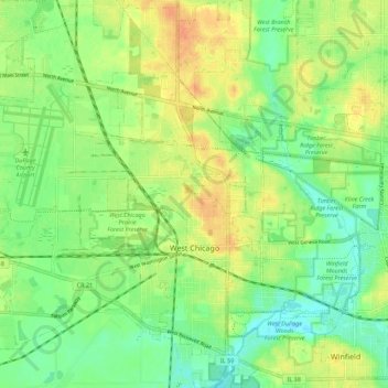
Nombre: Mapa topográfico West Chicago, altitud, relieve.
Lugar: West Chicago, DuPage County, Illinois, 60185, United States (41.85502 -88.26278 41.93726 -88.17515)
Altitud media: 232 m
Altitud mínima: 214 m
Altitud máxima: 252 m
Haz una donación
Otros mapas topográficos
Haga clic en un mapa para ver su topografía, su altitud y su relieve.
Elmhurst
United States > Illinois > DuPage County
Due to local topography, the town has had a tendency to flood in the past after large rainfalls; the city is currently undertaking a large effort to mitigate future flooding.
Altitud media: 207 m
Elmhurst
United States > Illinois > DuPage County
Due to local topography, the town has had a tendency to flood in the past after large rainfalls; the city is currently undertaking a large effort to mitigate future flooding.
Altitud media: 207 m
Haz una donación
Elmhurst
United States > Illinois > DuPage County
Due to local topography, the town has had a tendency to flood in the past after large rainfalls; the city is currently undertaking a large effort to mitigate future flooding.
Altitud media: 207 m