
Mapa topográfico Taliparamba
Haga clic en el mapa para ver la altitud.
Taliparamba
Taliparamba is located at 12°03′N 75°21′E / 12.05°N 75.35°E / 12.05; 75.35. It has an average elevation of 56 metres (184 ft) above sea level. The surrounding area (including the villages of Pattuvam, Pariyaram, Kuttiyeri, Karimbam, and Koonam) features lush green fields and low rolling hills. The Kuppam and Valapattanam rivers surround the town and the Arabian Sea is only 14 kilometres (8.7 mi) to the west of the city.
Acerca de este mapa
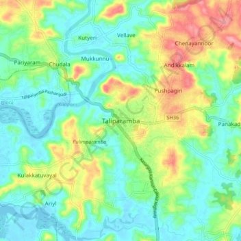
Nombre: Mapa topográfico Taliparamba, altitud, relieve.
Lugar: Taliparamba, Kannur, Kerala, 670141, India (11.99735 75.32028 12.07735 75.40028)
Altitud media: 35 m
Altitud mínima: -2 m
Altitud máxima: 110 m
Otros mapas topográficos
Haga clic en un mapa para ver su topografía, su altitud y su relieve.