
Haz una donación
Mapa topográfico Castle Rock
Haga clic en el mapa para ver la altitud.
Haz una donación
Acerca de este mapa
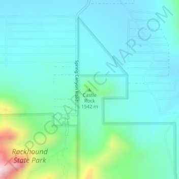
Nombre: Mapa topográfico Castle Rock, altitud, relieve.
Lugar: Castle Rock, Luna County, New Mexico, United States (32.15643 -107.61369 32.15653 -107.61359)
Altitud media: 1.466 m
Altitud mínima: 1.376 m
Altitud máxima: 1.866 m
Haz una donación
Otros mapas topográficos
Haga clic en un mapa para ver su topografía, su altitud y su relieve.
Deming
United States > New Mexico > Luna County
Deming is located within the Upper Chihuahuan Desert climate zone. The climate is dry, hot, and breezy. Summer temperatures often exceed 100 °F (38 °C), but the altitude (4,300 feet (1,300 m)) and dry air sometimes make summer days more comfortable than one would expect given the high temperature.
Altitud media: 1.327 m