
Mapa topográfico Herscheid
Mapa interactivo
Haga clic en el mapa para ver la altitud.
Herscheid
Herscheid is located in the Ebbegebirge ("Ebbe Mountains"), a part of the Sauerland mountains. Altitudes in the municipality extend from 250m above sea level in the valley of the Schwarze Ahe up to the highest elevation, the 663.3 metres (2,176 ft) high Nordhelle. The municipality covers an area of 58.924 square kilometres (22.751 sq mi), of which 58% is forest and 33% is used agriculturally. Most of the area is protected as a nature reserve, the Naturpark Ebbegebirge.
Acerca de este mapa
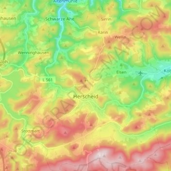
Nombre: Mapa topográfico Herscheid, altitud, relieve.
Altitud media: 441 m
Altitud mínima: 247 m
Altitud máxima: 664 m