
Mapa topográfico Mendip
Mapa interactivo
Haga clic en el mapa para ver la altitud.
Acerca de este mapa
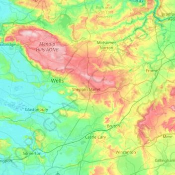
Nombre: Mapa topográfico Mendip, altitud, relieve.
Lugar: Mendip, Somerset, South West England, England, United Kingdom (51.06329 -2.84269 51.32571 -2.24440)
Altitud media: 98 m
Altitud mínima: -1 m
Altitud máxima: 323 m
Otros mapas topográficos
Haga clic en un mapa para ver su topografía, su altitud y su relieve.
Nettlebridge
United Kingdom > England > Mendip > Nettlebridge
Nettlebridge, Stratton on the Fosse, Mendip, Somerset, South West England, England, BA3 5AA, United Kingdom
Altitud media: 199 m