
Haz una donación
Mapa topográfico Lorton
Haga clic en el mapa para ver la altitud.
Haz una donación
Lorton
According to the United States Census Bureau, the Lorton CDP has a total area of 5.4 square miles (13.9 km2), of which 5.3 square miles (13.7 km2) is land and 0.1 square miles (0.2 km2), or 1.39%, is water. The elevation ranges from sea level at the Prince William County line (the Occoquan River) to slightly over 200 feet (61 m) along Furnace Road at the CDP's western edge.
Haz una donación
Acerca de este mapa
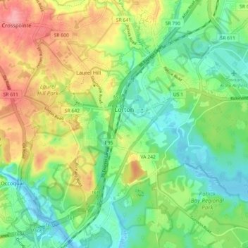
Nombre: Mapa topográfico Lorton, altitud, relieve.
Lugar: Lorton, Fairfax County, Virginia, United States (38.66687 -77.28193 38.73371 -77.19295)
Altitud media: 41 m
Altitud mínima: -4 m
Altitud máxima: 107 m
Haz una donación
Otros mapas topográficos
Haga clic en un mapa para ver su topografía, su altitud y su relieve.
Haz una donación
George Washington's Mount Vernon
United States > Virginia > Fairfax County > Mount Vernon
Visitors to Mount Vernon now see Washington's study, a room to which in the 18th century only a privileged few were granted entry. This simply furnished room has a combined bathroom, dressing room and office; the room was so private that few contemporary descriptions exist. Its walls are lined with naturally…
Altitud media: 14 m
Izaak Walton League of America - Arlington-Fairfax Chapter
United States > Virginia > Fairfax County > Centreville
Altitud media: 72 m
Haz una donación
Haz una donación
Haz una donación
Mount Vernon Community Park
United States > Virginia > Fairfax County > Fort Hunt > Snowden
Altitud media: 14 m
Haz una donación
Shirley Gate Park
United States > Virginia > Fairfax County > George Mason > Shirley Gate Park
Altitud media: 128 m
Haz una donación