
Gracias por apoyar a este sitio ❤️
Haz una donación
Haz una donación
Mapa topográfico Sun Prairie
Haga clic en el mapa para ver la altitud.
Gracias por apoyar a este sitio ❤️
Haz una donación
Haz una donación
Sun Prairie
The landscape of the city consists mostly of gently rolling hills and plains. The elevation of the city averages about 984 feet (300 m) above mean sea level.
Gracias por apoyar a este sitio ❤️
Haz una donación
Haz una donación
Acerca de este mapa
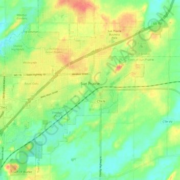
Nombre: Mapa topográfico Sun Prairie, altitud, relieve.
Lugar: Sun Prairie, Dane County, Wisconsin, United States (43.15056 -89.28821 43.21056 -89.18119)
Altitud media: 293 m
Altitud mínima: 272 m
Altitud máxima: 320 m
Gracias por apoyar a este sitio ❤️
Haz una donación
Haz una donación
Otros mapas topográficos
Haga clic en un mapa para ver su topografía, su altitud y su relieve.
Gracias por apoyar a este sitio ❤️
Haz una donación
Haz una donación
Gracias por apoyar a este sitio ❤️
Haz una donación
Haz una donación
Walking Iron County Park
United States > Wisconsin > Dane County > Town of Mazomanie
Altitud media: 236 m
Gracias por apoyar a este sitio ❤️
Haz una donación
Haz una donación