
Mapa topográfico Aniakchak National Monument
Mapa interactivo
Haga clic en el mapa para ver la altitud.
Acerca de este mapa
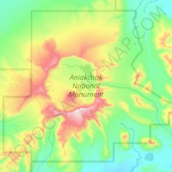
Nombre: Mapa topográfico Aniakchak National Monument, altitud, relieve.
Altitud media: 376 m
Altitud mínima: 31 m
Altitud máxima: 1.321 m
The national monument is centered on the 6-mile (9.7 km) diameter crater of ancient Mount Aniakchak, which was destroyed and the resulting crater formed during a caldera collapse event about 3,700 years ago. The original mountain, about 7,000 feet (2,100 m) tall, collapsed into its magma chamber, leaving an approximate 3,300-foot (1,000 m) deep summit crater. (The elevation of the high point on the crater rim, Aniakchak Peak, is approximately 4,380 feet. The elevation of the low point of the caldera floor, at the mouth of Surprise Lake and the beginning of the Aniakchak River, is approximately 1,055 feet.) The monument and surrounding preserve include the volcanic feature, the wild Aniakchak River, the Bristol Bay coastal habitat, and portions of the coast of the Pacific Ocean.
Otros mapas topográficos
Haga clic en un mapa para ver su topografía, su altitud y su relieve.
Alagnak River
United States > Alaska > Lake and Peninsula
Alagnak River, Lake and Peninsula, Alaska, United States
Altitud media: 16 m
Lake Clark
United States > Alaska > Lake and Peninsula
Lake Clark, Lake and Peninsula, Alaska, United States
Altitud media: 477 m
Port Alsworth
United States > Alaska > Lake and Peninsula
Port Alsworth, Lake and Peninsula, Alaska, 99653, United States
Altitud media: 93 m
Nondalton
United States > Alaska > Lake and Peninsula
Nondalton, Lake and Peninsula, Alaska, 99640, United States
Altitud media: 138 m