
Mapa topográfico Gomoa Central District
Mapa interactivo
Haga clic en el mapa para ver la altitud.
Acerca de este mapa
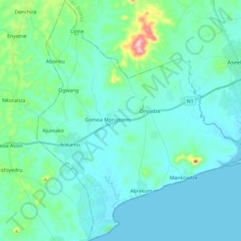
Nombre: Mapa topográfico Gomoa Central District, altitud, relieve.
Lugar: Gomoa Central District, Central Region, Ghana (5.27450 -0.78208 5.43434 -0.64240)
Altitud media: 35 m
Altitud mínima: -1 m
Altitud máxima: 255 m
Otros mapas topográficos
Haga clic en un mapa para ver su topografía, su altitud y su relieve.
Breman Asikuma
Ghana > Central Region > Asikuma/Odoben/Brakwa District
Breman Asikuma, Asikuma/Odoben/Brakwa District, Central Region, Ghana
Altitud media: 85 m
Komenda
Ghana > Central Region > Komenda/Edina/Eguafo/Abirem Municipal District
Komenda, Komenda/Edina/Eguafo/Abirem Municipal District, Central Region, Ghana
Altitud media: 5 m
Upper Denkyira West District
Upper Denkyira West District, Central Region, Ghana
Altitud media: 142 m
Cape Coast
Ghana > Central Region > Cape Coast Metropolitan District
Cape Coast, Cape Coast Metropolitan District, Central Region, CC-008-3586, Ghana
Altitud media: 22 m
Upper Denkyira East Municipal District
Ghana > Central Region > Upper Denkyira East Municipal District
Upper Denkyira East Municipal District, Central Region, Ghana
Altitud media: 140 m
Awutu Breku
Ghana > Central Region > Awutu Senya West District
Awutu Breku, Awutu Senya West District, Central Region, Ghana
Altitud media: 103 m
Kasoa
Ghana > Central Region > Gomoa East District
Kasoa, Gomoa East District, Central Region, Ghana
Altitud media: 31 m
Elmina
Ghana > Central Region > Komenda/Edina/Eguafo/Abirem Municipal District
Elmina, Komenda/Edina/Eguafo/Abirem Municipal District, Central Region, Ghana
Altitud media: 6 m
Awutu Bereku
Ghana > Central Region > Awutu Senya West District
Awutu Bereku, Awutu Senya West District, Central Region, Ghana
Altitud media: 57 m