
Mapa topográfico Yardley Gobion
Mapa interactivo
Haga clic en el mapa para ver la altitud.
Acerca de este mapa
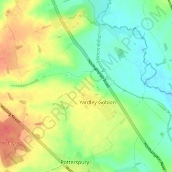
Nombre: Mapa topográfico Yardley Gobion, altitud, relieve.
Altitud media: 89 m
Altitud mínima: 65 m
Altitud máxima: 123 m
Otros mapas topográficos
Haga clic en un mapa para ver su topografía, su altitud y su relieve.
Bengal
United Kingdom > England > South Northamptonshire > Greens Norton > Bengal
Bengal, Greens Norton, South Northamptonshire, Northamptonshire, East Midlands, England, NN12 8BG, United Kingdom
Altitud media: 112 m
Nether Heyford
United Kingdom > England > South Northamptonshire > Nether Heyford
Nether Heyford, South Northamptonshire, Northamptonshire, East Midlands, England, NN7 3LE, United Kingdom
Altitud media: 95 m
Adstone
United Kingdom > England > South Northamptonshire
Adstone, South Northamptonshire, Northamptonshire, East Midlands, England, United Kingdom
Altitud media: 150 m
South Northamptonshire
United Kingdom > England > South Northamptonshire
South Northamptonshire, West Northamptonshire, East Midlands, England, United Kingdom
Altitud media: 115 m
Deanshanger
United Kingdom > England > South Northamptonshire
Deanshanger, South Northamptonshire, Northamptonshire, East Midlands, England, United Kingdom
Altitud media: 87 m
Whittlebury
United Kingdom > England > South Northamptonshire
Whittlebury, South Northamptonshire, Northamptonshire, East Midlands, England, United Kingdom
Altitud media: 126 m
Greatworth
United Kingdom > England > South Northamptonshire
Greatworth, South Northamptonshire, Northamptonshire, East Midlands, England, United Kingdom
Altitud media: 146 m