
Gracias por apoyar a este sitio ❤️
Haz una donación
Haz una donación
Mapa topográfico Les Rouves
Haga clic en el mapa para ver la altitud.
Gracias por apoyar a este sitio ❤️
Haz una donación
Haz una donación
Acerca de este mapa
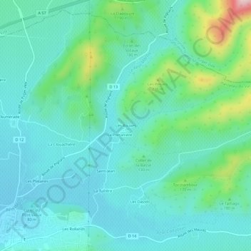
Nombre: Mapa topográfico Les Rouves, altitud, relieve.
Altitud media: 119 m
Altitud mínima: 59 m
Altitud máxima: 357 m
Gracias por apoyar a este sitio ❤️
Haz una donación
Haz una donación
Otros mapas topográficos
Haga clic en un mapa para ver su topografía, su altitud y su relieve.
Le Réal Martin
France > Provence-Alpes-Côte d'Azur > Var > Pierrefeu-du-Var
La longueur de son cours d'eau est de 28 km. Le Réal Martin prend sa source, à l'altitude 215 mètres, sur la commune de Pignans, près du lieu-dit les Plaines, au nord de la Forêt domaniale des Maures et des sommets Le Cros de Panau (684 m) et Notre-Dame des Anges (768 m).
Altitud media: 176 m