
Mapa topográfico Red Lodge
Mapa interactivo
Haga clic en el mapa para ver la altitud.
Red Lodge
Red Lodge experiences a continental climate (Köppen Dfb) with cold, somewhat dry winters and warm, wetter summers. Summers are cooler than in areas of Montana further north, due to the high elevation. Winters however, are milder than areas further to the east due to the chinook wind influence, as with most of Montana.
Acerca de este mapa
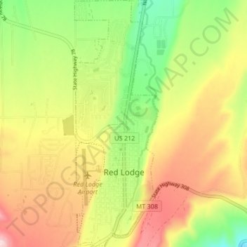
Nombre: Mapa topográfico Red Lodge, altitud, relieve.
Lugar: Red Lodge, Carbon County, Montana, 59068, United States (45.17150 -109.26051 45.21889 -109.23767)
Altitud media: 1.720 m
Altitud mínima: 1.595 m
Altitud máxima: 1.850 m
Otros mapas topográficos
Haga clic en un mapa para ver su topografía, su altitud y su relieve.