Geolocalizar

Mapa topográfico Russell

Mapa interactivo

Haga clic en el mapa para ver la altitud.

Acerca de este mapa

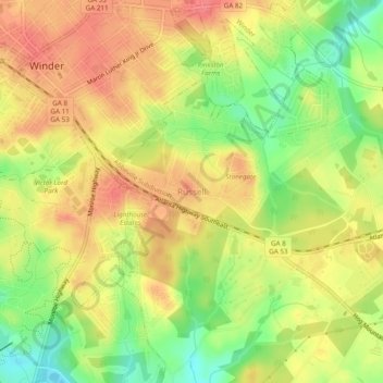
Nombre: Mapa topográfico Russell, altitud, relieve.

Lugar: Russell, Barrow County, Georgia, 30680, United States (33.95872 -83.72017 33.99872 -83.68017)

Altitud media: 279 m

Altitud mínima: 240 m

Altitud máxima: 308 m

Otros mapas topográficos

Haga clic en un mapa para ver su topografía, su altitud y su relieve.

Fort Yargo State Park

United States > Georgia > Barrow County > Winder

Fort Yargo State Park, Winder, Barrow County, Georgia, United States

Altitud media: 270 m

Auburn

United States > Georgia > Barrow County

Auburn, Barrow County, Georgia, 30011, United States

Altitud media: 300 m

Statham

United States > Georgia > Barrow County

Statham, Barrow County, Georgia, United States

Altitud media: 261 m

Carl

United States > Georgia > Barrow County

Carl, Barrow County, Georgia, United States

Altitud media: 317 m

Bethlehem

United States > Georgia > Barrow County

Bethlehem, Barrow County, Georgia, United States

Altitud media: 258 m

Winder

United States > Georgia > Barrow County

Winder, Barrow County, Georgia, United States

Altitud media: 274 m