
Mapa topográfico Lupane
Mapa interactivo
Haga clic en el mapa para ver la altitud.
Acerca de este mapa
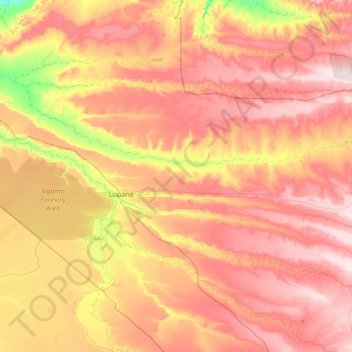
Nombre: Mapa topográfico Lupane, altitud, relieve.
Lugar: Lupane, Matabeleland North Province, Zimbabwe (-19.50360 27.34394 -18.23207 28.42569)
Altitud media: 1.042 m
Altitud mínima: 860 m
Altitud máxima: 1.218 m
Lupane ( luːpɑːnɛ) District is located in the Matabeleland North Province of Zimbabwe, and it is also the Provincial Capital. The District is situated at an elevation of 976 m with a population of 198,600 inhabitants by 2019. Lupane Town is the main center of the district located 172 km from Bulawayo along the A8 Victoria Falls Road. The Government Provincial Administrative offices are located at the Town Centre. A new university near the Town has been established under the name Lupane State University, which caters for the region and beyond. The word Lupane is thought to be a Kalanga or Lozwi word.
Otros mapas topográficos
Haga clic en un mapa para ver su topografía, su altitud y su relieve.
Hwange
Zimbabwe > Matabeleland North Province
Hwange, Matabeleland North Province, Zimbabwe
Altitud media: 968 m
Chizarira National Park
Zimbabwe > Matabeleland North Province
Chizarira National Park, Matabeleland North Province, Zimbabwe
Altitud media: 871 m
14 Rainbow Falls
Zimbabwe > Matabeleland North Province > Hwange > Victoria Falls
14 Rainbow Falls, Livingstone Way, Victoria Falls, Hwange, Matabeleland North Province, Zimbabwe
Altitud media: 873 m
Binga
Zimbabwe > Matabeleland North Province
Binga, Matabeleland North Province, Zimbabwe
Altitud media: 820 m
Hwange National Park
Zimbabwe > Matabeleland North Province > Hwange
Hwange National Park, Hwange, Matabeleland North Province, Zimbabwe
Altitud media: 1.000 m
Batoka Gorge
Zimbabwe > Matabeleland North Province > Hwange > Victoria Falls
Batoka Gorge, Victoria Falls, Hwange, Matabeleland North Province, Zimbabwe
Altitud media: 861 m