
Mapa topográfico Ahanta West Municipal District
Mapa interactivo
Haga clic en el mapa para ver la altitud.
Acerca de este mapa
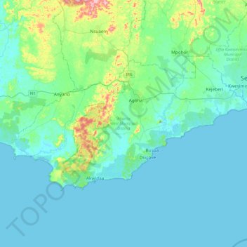
Nombre: Mapa topográfico Ahanta West Municipal District, altitud, relieve.
Lugar: Ahanta West Municipal District, Western Region, Ghana (4.73934 -2.18126 4.96351 -1.76785)
Altitud media: 28 m
Altitud mínima: -1 m
Altitud máxima: 198 m
Otros mapas topográficos
Haga clic en un mapa para ver su topografía, su altitud y su relieve.
Ellembelle District
Ellembelle District, Western Region, Ghana
Altitud media: 52 m
Tarkwa
Ghana > Western Region > Tarkwa-Nsuaem Municipal District
Tarkwa, Tarkwa-Nsuaem Municipal District, Western Region, Ghana
Altitud media: 96 m
Half Assini
Ghana > Western Region > Jomoro Municipal District
Half Assini, Jomoro Municipal District, Western Region, Ghana
Altitud media: 7 m
Huni Valley
Ghana > Western Region > Prestea-Huni Valley Municipal District
Huni Valley, Prestea-Huni Valley Municipal District, Western Region, Ghana
Altitud media: 140 m
Busua
Ghana > Western Region > Ahanta West Municipal District
Busua, Ahanta West Municipal District, Western Region, Ghana
Altitud media: 13 m
Asankrangwa
Ghana > Western Region > Amenfi West Municipal District > Asankrangwa
Asankrangwa, Amenfi West Municipal District, Western Region, POST OFFICE BOX 6, Ghana
Altitud media: 107 m
Sekondi
Ghana > Western Region > Sekondi Takoradi Metropolitan District > Sekondi
Sekondi, Sekondi Takoradi Metropolitan District, Western Region, Ghana
Altitud media: 13 m
Wassa Akropong
Ghana > Western Region > Wassa Akropong
Wassa Akropong, Western Region, Ghana
Altitud media: 85 m
Takoradi
Ghana > Western Region > Sekondi Takoradi Metropolitan District
Takoradi, Sekondi Takoradi Metropolitan District, Western Region, Ghana
Altitud media: 4 m
Shama
Ghana > Western Region > Shama District
Shama, Shama District, Western Region, Ghana
Altitud media: 8 m
Mpohor
Ghana > Western Region > Mpohor District
Mpohor, Mpohor District, Western Region, Ghana
Altitud media: 36 m