
Haz una donación
Mapa topográfico Hamilton
Haga clic en el mapa para ver la altitud.
Haz una donación
Hamilton
According to the United States Census Bureau, the town has a total area of 14.9 square miles (38.6 km2), of which 14.2 square miles (36.7 km2) is land and 0.73 square miles (1.9 km2), or 4.89%, is water. Hamilton lies 5 miles (8 km) inland from Massachusetts Bay, and both the eastern and western portion of town are bordered by water, with the Ipswich River to the west and Chebacco Lake and several other small ponds to the east. The highest point in town is found on Blueberry Hill in Bradley Palmer State Park, with an elevation of at least 215 feet (66 m), according to the most recent (2011-2012) USGS 7.5-minute topographical map. Several areas of town are protected, including Myopia Hunt Club and parts of Bradley Palmer State Park, Appleton Farm Grass Rides, and the Ipswich River Wildlife Sanctuary.
Haz una donación
Acerca de este mapa
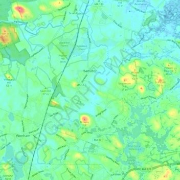
Nombre: Mapa topográfico Hamilton, altitud, relieve.
Lugar: Hamilton, Essex County, Massachusetts, United States (42.59341 -70.91991 42.66029 -70.80083)
Altitud media: 19 m
Altitud mínima: -2 m
Altitud máxima: 82 m
Haz una donación
Otros mapas topográficos
Haga clic en un mapa para ver su topografía, su altitud y su relieve.
Haz una donación
Little River Marshes
United States > Massachusetts > Essex County > Gloucester > West Gloucester
Altitud media: 27 m
Haz una donación
Blackwater River
United States > Massachusetts > Essex County > Salisbury > Salisbury Beach
Altitud media: 4 m
Haz una donación
Haz una donación
Haz una donación
Haz una donación
Haz una donación
Haz una donación
Haz una donación
Kettle Cove Village
United States > Massachusetts > Essex County > Manchester-by-the-Sea
Altitud media: 18 m
Haz una donación
Haz una donación
Haz una donación
Haz una donación
Haz una donación
Amesbury
United States > Massachusetts > Essex County > Amesbury
Amesbury is located at 42°51′29″N 70°55′50″W / 42.85806°N 70.93056°W / 42.85806; -70.93056. According to the United States Census Bureau, the city has a total area of 13.7 square miles (35.5 km2), of which 12.3 square miles (31.8 km2) is land and 1.5 square miles (3.8 km2), or 10.65%, is…
Altitud media: 24 m
East Parish
United States > Massachusetts > Essex County > Boxford > Boxford > East Parish
Altitud media: 38 m
Haz una donación
Haz una donación