
Haz una donación
Mapa topográfico Milford
Haga clic en el mapa para ver la altitud.
Haz una donación
Acerca de este mapa
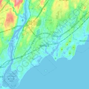
Nombre: Mapa topográfico Milford, altitud, relieve.
Altitud media: 18 m
Altitud mínima: -6 m
Altitud máxima: 117 m
Haz una donación
Otros mapas topográficos
Haga clic en un mapa para ver su topografía, su altitud y su relieve.
Sea Bluff
United States > Connecticut > South Central Connecticut Planning Region > West Haven > West Shore
Altitud media: 14 m
Killingworth Court
United States > Connecticut > South Central Connecticut Planning Region > New Haven
Altitud media: 13 m
Hein Trails
United States > Connecticut > South Central Connecticut Planning Region > Bethany > Davidsons Corner
Altitud media: 175 m
Indian Neck
United States > Connecticut > South Central Connecticut Planning Region > Branford
Altitud media: 4 m
Haz una donación
Northford
United States > Connecticut > South Central Connecticut Planning Region > North Branford
Altitud media: 71 m
Derby
United States > Connecticut > South Central Connecticut Planning Region
According to the United States Census Bureau, the town has a total area of 5.4 square miles (8.7 km2), of which, 5.0 square miles (13 km2) is land and 0.4 square miles (1.0 km2) (7.41%) is water. The city is home to the 417 acres (0.652 sq mi) Osbornedale State Park. Derby is divided into two main sections by…
Altitud media: 79 m
Momauguin
United States > Connecticut > South Central Connecticut Planning Region > East Haven
Altitud media: 3 m
Haz una donación
Indian Cave
United States > Connecticut > South Central Connecticut Planning Region > Guilford
Altitud media: 25 m
North Madison
United States > Connecticut > South Central Connecticut Planning Region > Madison
Altitud media: 91 m
Nut Plains
United States > Connecticut > South Central Connecticut Planning Region > Guilford
Altitud media: 35 m
Fort Trumbull
United States > Connecticut > South Central Connecticut Planning Region > Milford
Altitud media: 7 m
Haz una donación
Branford Court
United States > Connecticut > South Central Connecticut Planning Region > New Haven
Altitud media: 13 m
West Shore
United States > Connecticut > South Central Connecticut Planning Region > West Haven
Altitud media: 9 m
North Haven Bridge
United States > Connecticut > South Central Connecticut Planning Region > North Haven
Altitud media: 22 m
Lake Whitney
United States > Connecticut > South Central Connecticut Planning Region > Hamden > Whitneyville
Altitud media: 25 m
Haz una donación
West Shore
United States > Connecticut > South Central Connecticut Planning Region > West Haven
Altitud media: 9 m
South End Point
United States > Connecticut > South Central Connecticut Planning Region > East Haven > Momauguin
Altitud media: 2 m
Lake Whitney
United States > Connecticut > South Central Connecticut Planning Region > Hamden
Altitud media: 25 m
Forest Heights
United States > Connecticut > South Central Connecticut Planning Region > Milford
Altitud media: 19 m
Haz una donación
Silver Beach
United States > Connecticut > South Central Connecticut Planning Region > Milford > Fort Trumbull
Altitud media: 5 m
Branford Hills
United States > Connecticut > South Central Connecticut Planning Region > Branford
Altitud media: 12 m
East Peak
United States > Connecticut > South Central Connecticut Planning Region > Meriden
Altitud media: 154 m
Momauguin
United States > Connecticut > South Central Connecticut Planning Region > East Haven
Altitud media: 3 m
Haz una donación
Silver Beach
United States > Connecticut > South Central Connecticut Planning Region > Milford
Altitud media: 5 m
Nut Plains
United States > Connecticut > South Central Connecticut Planning Region > Guilford
Altitud media: 35 m
South Meriden
United States > Connecticut > South Central Connecticut Planning Region > Meriden
Altitud media: 55 m
Bayview
United States > Connecticut > South Central Connecticut Planning Region > Milford
Altitud media: 5 m
Haz una donación
Brightview
United States > Connecticut > South Central Connecticut Planning Region > New Haven
Altitud media: 5 m
Fort Trumbull
United States > Connecticut > South Central Connecticut Planning Region > Milford
Altitud media: 7 m
Sea Bluff
United States > Connecticut > South Central Connecticut Planning Region > West Haven > West Shore
Altitud media: 14 m
Mount Carmel Center
United States > Connecticut > South Central Connecticut Planning Region > Hamden
Altitud media: 79 m
Haz una donación
Morningside
United States > Connecticut > South Central Connecticut Planning Region > Milford
Altitud media: 5 m
East River
United States > Connecticut > South Central Connecticut Planning Region > Madison
Altitud media: 9 m
Big Indian
United States > Connecticut > South Central Connecticut Planning Region > Guilford
Altitud media: 41 m
Sunset Hill
United States > Connecticut > South Central Connecticut Planning Region > Branford
Altitud media: 12 m
Haz una donación
Sea Bluff
United States > Connecticut > South Central Connecticut Planning Region > West Haven > West Shore
Altitud media: 14 m
Clark Hill
United States > Connecticut > South Central Connecticut Planning Region > Milford
Altitud media: 11 m
Peter's Rock
United States > Connecticut > South Central Connecticut Planning Region > North Haven
Altitud media: 38 m
Quinnipiac
United States > Connecticut > South Central Connecticut Planning Region > Wallingford
Altitud media: 31 m
Haz una donación
North Branford Town Green
United States > Connecticut > South Central Connecticut Planning Region > North Branford
Altitud media: 44 m
Fair Haven East
United States > Connecticut > South Central Connecticut Planning Region > New Haven
Altitud media: 14 m
Allingtown
United States > Connecticut > South Central Connecticut Planning Region > West Haven
Altitud media: 26 m