
Haz una donación
Mapa topográfico Salesforce Park
Haga clic en el mapa para ver la altitud.
Haz una donación
Acerca de este mapa
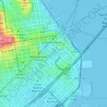
Nombre: Mapa topográfico Salesforce Park, altitud, relieve.
Altitud media: 16 m
Altitud mínima: -5 m
Altitud máxima: 104 m
Haz una donación
Otros mapas topográficos
Haga clic en un mapa para ver su topografía, su altitud y su relieve.
Alcatraz Island
United States > California > San Francisco
Alcatraz Island view from the west. Image shot from an altitude of approximately 1,800 ft (549 m).
Altitud media: 0 m
Haz una donación
Mount Davidson
United States > California > San Francisco
Mount Davidson is the highest natural point in San Francisco, California, with an elevation of 928 feet (283 m). It is located near the geographical center of the city, south of Twin Peaks and Portola Drive and to the west of Diamond Heights and Glen Park. It dominates the southeastern view from most of…
Altitud media: 138 m
Haz una donación