
Gracias por apoyar a este sitio ❤️
Haz una donación
Haz una donación
Mapa topográfico Sydney Gardens
Haga clic en el mapa para ver la altitud.
Gracias por apoyar a este sitio ❤️
Haz una donación
Haz una donación
Acerca de este mapa
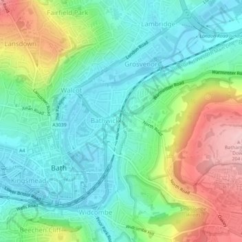
Nombre: Mapa topográfico Sydney Gardens, altitud, relieve.
Altitud media: 77 m
Altitud mínima: 16 m
Altitud máxima: 206 m
Gracias por apoyar a este sitio ❤️
Haz una donación
Haz una donación
Otros mapas topográficos
Haga clic en un mapa para ver su topografía, su altitud y su relieve.
Bathwick Hill
United Kingdom > England > Bath and North East Somerset > Bath
Number 1 (Bathwick Lodge) is a 2-storey villa with a steep Mansard room, built in 1825, extended in 1840 and the late C19. Probably by John Pinch the Elder.[4] Number 2 is from the early 19th century and has shutters over the windows.[11] Number 3 includes a porch which is elaborately enriched with carving,…
Altitud media: 93 m