
Mapa topográfico Près d'Eglise
Mapa interactivo
Haga clic en el mapa para ver la altitud.
Acerca de este mapa
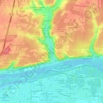
Nombre: Mapa topográfico Près d'Eglise, altitud, relieve.
Altitud media: 78 m
Altitud mínima: 44 m
Altitud máxima: 116 m
Otros mapas topográficos
Haga clic en un mapa para ver su topografía, su altitud y su relieve.
La Grande Rue
France > Centre-Val de Loire > Indre-et-Loire > Rochecorbon
La Grande Rue, Rochecorbon, Tours, Indre-et-Loire, Centre-Val de Loire, France métropolitaine, 37210, France
Altitud media: 77 m
Mont-Guerre
France > Centre-Val de Loire > Indre-et-Loire > Rochecorbon
Mont-Guerre, Rochecorbon, Arrondissement de Tours, Indre-et-Loire, Centre-Val de Loire, France métropolitaine, 37210, France
Altitud media: 73 m