
Haz una donación
Mapa topográfico Snake Range
Haga clic en el mapa para ver la altitud.
Haz una donación
Snake Range
The Snake Range is a mountain range in White Pine County, Nevada, United States. The south-central portion of the range is included within Great Basin National Park, with most of the remainder included within the Humboldt-Toiyabe National Forest. The range reaches a maximum elevation of 13,065 feet (3,982 m) at the summit of Wheeler Peak, the tallest independent mountain within Nevada and the second highest point within the state (the highest point being Boundary Peak). The range also contains four of the five highest mountain peaks in Nevada, including all peaks greater than 12,000 feet (3,658 m) except for Boundary Peak.
Haz una donación
Acerca de este mapa
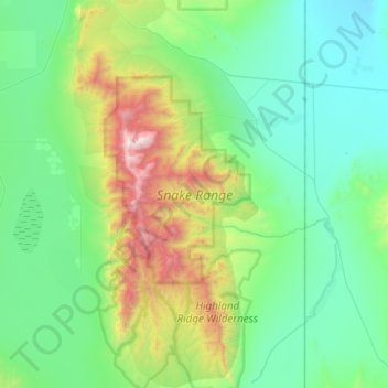
Nombre: Mapa topográfico Snake Range, altitud, relieve.
Lugar: Snake Range, White Pine County, Nevada, United States (38.69341 -114.40564 39.15549 -114.11983)
Altitud media: 1.996 m
Altitud mínima: 1.505 m
Altitud máxima: 3.927 m
Haz una donación
Otros mapas topográficos
Haga clic en un mapa para ver su topografía, su altitud y su relieve.