
Haz una donación
Mapa topográfico Porto Santo
Haga clic en el mapa para ver la altitud.
Haz una donación
Porto Santo
The southwest part of the island, although relatively flat, includes a series of elevations 100 meters in height or greater, such as Pico Ana Fereira (283 meters), Pico do Espigão (270 meters) and the Cabeço do Zimbralinho (183 meters). The slope of the western part of the island slopes from 150 meters to the south coast reaching the sandy beaches of Porto Santo. A third system, in the west-northwest, that includes Cabeço da Bárbara Gomes (227 meters) and Cabeço das Canelinhas (176 meters) is distinct from the areas identified. The island is encircled by an oceanic platform between 20 and 37 km2, with a minimum depth of 8 meters (Baixa do Noroeste), and limited by the flanks of a large submarine volcano.
Haz una donación
Acerca de este mapa
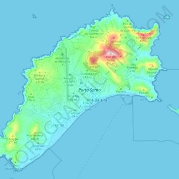
Nombre: Mapa topográfico Porto Santo, altitud, relieve.
Lugar: Porto Santo, Madeira, Portugal (33.02412 -16.39789 33.10745 -16.28928)
Altitud media: 45 m
Altitud mínima: -1 m
Altitud máxima: 489 m
Haz una donación