
Haz una donación
Mapa topográfico Waukegan
Haga clic en el mapa para ver la altitud.
Haz una donación
Waukegan
Waukegan is located at 42°22′13″N 87°52′16″W / 42.37028°N 87.87111°W / 42.37028; -87.87111 (42.3703140, −87.8711404). Waukegan is on the shore of Lake Michigan, about 11 miles (18 km) south of the border with Wisconsin and 37 miles (60 km) north of downtown Chicago at an elevation around 650 feet (200 m) above sea level. Chicago has two major streets that venture north to Waukegan, one being Sheridan Road, which extends north from Diversey Parkway in Lincoln Park. The second street is Milwaukee Avenue, which starts at the intersection of Desplaines Street and Kinzie Street in downtown Chicago.
Haz una donación
Acerca de este mapa
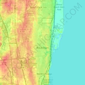
Nombre: Mapa topográfico Waukegan, altitud, relieve.
Lugar: Waukegan, Lake County, Illinois, United States (42.30938 -87.96442 42.43266 -87.80421)
Altitud media: 197 m
Altitud mínima: 172 m
Altitud máxima: 236 m
Haz una donación
Otros mapas topográficos
Haga clic en un mapa para ver su topografía, su altitud y su relieve.
Haz una donación
Haz una donación
Haz una donación
Lake Naomi
United States > Illinois > Lake County > Hawthorn Woods > White Birch Lakes
Altitud media: 261 m