
Haz una donación
Mapa topográfico Roseburg
Haga clic en el mapa para ver la altitud.
Haz una donación
Roseburg
Roseburg's elevation is approximately 500 feet (150 m). Its highest point is Mount Nebo, a 1,200-foot (370 m) hill to the west of Interstate 5. Through the 1980s, it was known for its band of 10-20 feral angora goats. Residents said they could predict the weather by watching where the goats were on the mountain; if they were high, the weather would be good. If rain was pending, the goats moved to lower levels. Because the goats wandered across the freeway for grazing, they were a risk to traffic. In the 1980s, they were rounded up and placed for adoption.
Haz una donación
Acerca de este mapa
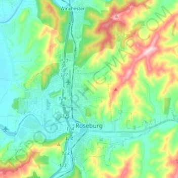
Nombre: Mapa topográfico Roseburg, altitud, relieve.
Lugar: Roseburg, Douglas County, Oregon, United States (43.19052 -123.40198 43.28152 -123.27021)
Altitud media: 239 m
Altitud mínima: 116 m
Altitud máxima: 546 m
Haz una donación
Otros mapas topográficos
Haga clic en un mapa para ver su topografía, su altitud y su relieve.
Haz una donación
Haz una donación
Haz una donación